ABOUT InSAR
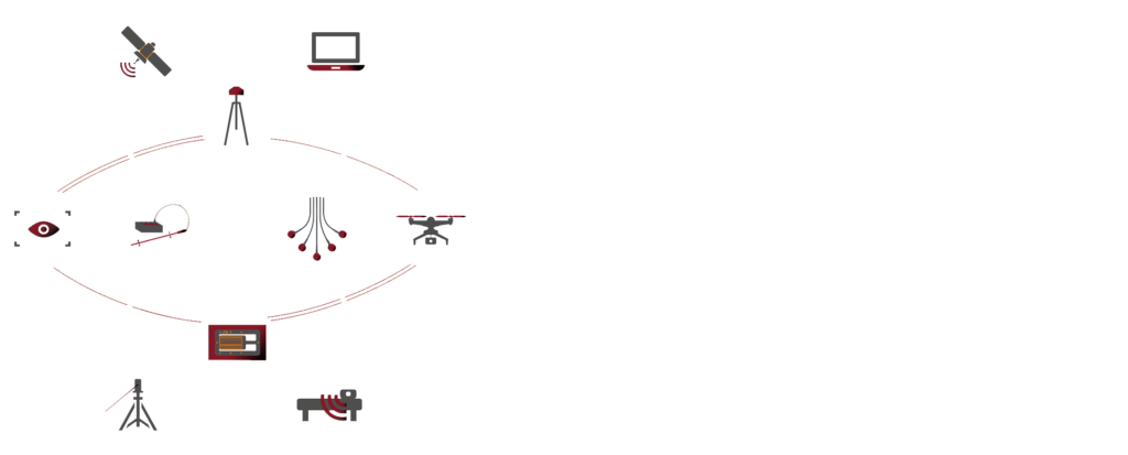
Interferometric Synthetic Aperture Radar (InSAR) is a powerful technique for the estimation of multi-temporal surface deformation processes, allowing a detailed monitoring of ground and structures through the use of sensors installed on satellite (A-DInSAR) and terrestrial (TInSAR) platforms.
One of the greatest value and peculiarity of Satellite InSAR technology is the capability to perform historical displacement analysis, thanks to the archives of imagery available since 1992. Furthermore, thanks to the new generation of satellites and their acquisition programs, it is nowadays possible to perform detailed analysis for monitoring purposes.
Last generation of algorithms developed by NHAZCA allows to customize the InSAR analysis for different purposes and applications, such as: land use planning, urban planning, slope stability assessment, monitoring of subsidence processes (e.g. due to oil and gas or water extraction), large structure/infrastructure monitoring (dams, buildings, highways, viaducts, etc.), tunneling-induced ground deformation monitoring, monitoring of volcanic and seismic activity, etc.
NHAZCA team is able to process a wide range of satellite SAR data, characterized by different technical specifications and, therefore, suitable for different fields of application, such as: ERS1 and ERS2, ENVISAT, RADARSAT-1, RADARSAT-2, ALOS-PALSAR, ALOS2, TerraSAR-X, COSMO-SkyMed, SENTINEL-1A and SENTINEL 1-B.
Besides satellite-based sensors, ground-based sensors (TInSAR) are in use for a variety of monitoring applications. Terrestrial Interferometry allows the monitoring of displacements of both anthropogenic elements (structures and infrastructures) and natural elements (landslides, rock slopes, volcanoes, etc.). The high accuracy in the measurements without the need of installing artificial reflectors and the high data sampling frequency, allow to collect information simultaneously on the whole irradiated scenario, with sub-millimeter accuracies.
By integrating the SAR configuration (with the sensor moving along rail), special algorithms developed by NHAZCA and 3D models collected by Laser Scanner surveys, NHAZCA is able to produce 3D displacement maps to support the identification, mapping and characterization of unstable sectors.
Moreover, by exploiting the TInRAR configuration (Real Aperture Radar), an interferometry-based system for remote static and dynamic analysis, NHAZCA is able to perform Structural Health Monitoring of bridges, ancient masonry towers, etc. identifying the modal parameters of the structures under investigation.
Finally, thanks to quick installation protocols and the development of TRIVIA, the data processing proprietary software, NHAZCA can provide real-time monitoring services for different applications, including early warning for civil protection purposes.
OUR SATELLITE TOOLS


InSAR VISUALIZATION TOOL
The InSAR Visualization Tool is our web based platform for the monitoring data distribution which allows to explore the interferometric products and analyse each measurement point, observing the time series of displacement.
The platform supports different kind of monitoring data, acquired with different types of monitoring systems, offering the opportunity to manage complex projects thanks also to its customizable and user friendly interface.
INSarPECT APP
INSarPECT supports the field surveys as you can combine and superimpose satellite InSAR data with your collected field data, simply through your mobile devices. Your field teams can then collect records including geo-referred information such as text, photos, videos, vocal notes, and more.
This ensure that any inspection report is linked exactly to the location where issues were found. No more pen and paper needed. Everything will be recorded as is and synchronized with the server and all other linked mobile devices. INSarPECT also assures that InSAR results are used to their maximum potential, closing the loop between satellite and field work.
The added value provided by PS ToolBox consists in the effective mapping and understanding the detected deformation processes, in assessing the health and the potential risk of structures and infrastructures, also for predictive maintenance purposes.
PS ToolBox
PS ToolBox is the new GIS plugin for the post-processing of InSAR data conceived and developed by NHAZCA S.r.l.
The plugin includes a series of tools for the spatialization, integration and interactive analysis of PSI data such as:
- HeatMap;
- KMZ export;
- Filtering;
- Interferometric Sections;
- Linear infrastructures – interference analysis;
- Vectorial decomposition – from ascending and descending orbits datasets;
- PS Time Series – optimized visualization tool;
- Trend Change Detection – analysis of time series of displacement.
OUR TERRESTRIAL TOOLS


TRIVIA – Terrestrial Radar Interferometry VIsualization and Analysis
TRIVIA software is the result of more than 10 years long experience in Terrestrial SAR Interferometry gained in the frame of tenths of projects on landslides, dams, rock-slopes, bridges, buildings etc.
The software is able to perform advanced analyses of Terrestrial SAR images, processing data from several radar manufacturers like IDS GeoRadar, MetaSensing and Echoes. By using TRIVIA, NHAZCA is able to support clients with excellent real-time data processing capabilities.
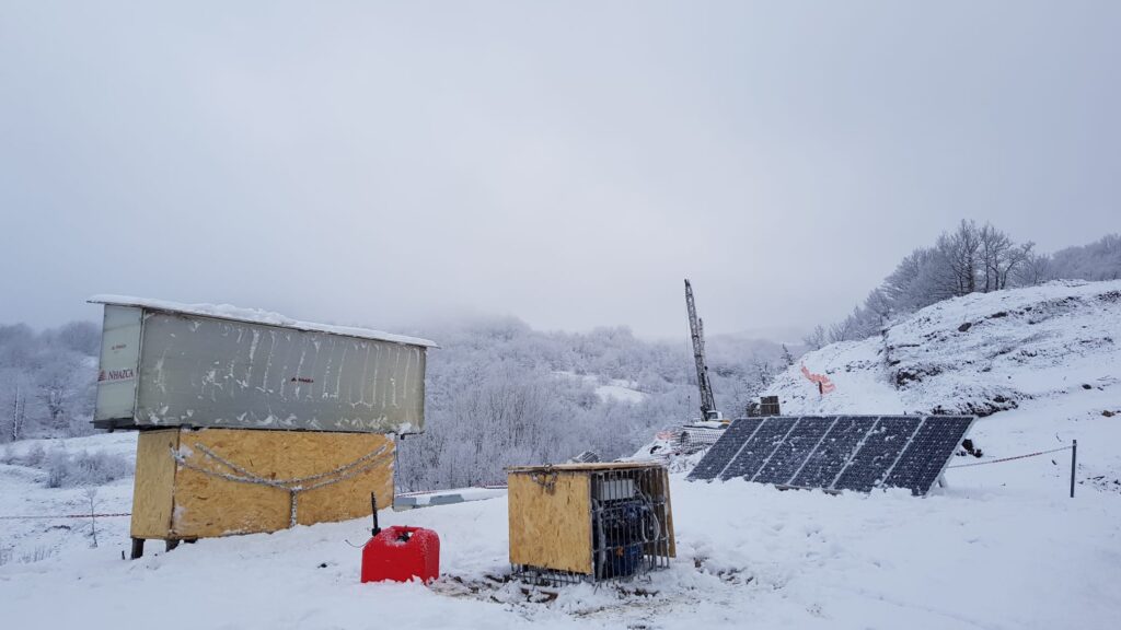
QUIB – Quick Installation Basement
The QUIB is an easy to transport modular basement designed and realized by NHAZCA for the quick installation (about 2 hours) of a terrestrial interferometric monitoring platform. Once installed, the size of the system is 280×60×200 cm.
Moreover, the QUIB can be installed on every kind of ground thanks to its eight adjustable legs. It can be completely enclosed by polycarbonate or wood panels for the equipment safety. Thanks to the QUIB, NHAZCA can perform the installation of monitoring platform in less than 24 hours from the call in emergency conditions. Furthermore, the rigorous design technical solutions comply with the requirements of prompt intervention protocols developed by NHAZCA for civil protection purposes.
RAPS – Remote Area Power Supply
RAPS is a stand-alone power supply system, consisting of a modular photovoltaic system, storage batteries that accumulate the surplus energy produced during sunny hours to make it available at various times and a backup electric generator, allowing the continuous power supply even in case of emergency.
RAPS is thus able to produce electricity to supply the TInSAR system, even in remote areas. Thanks to an energy box, built ad-hoc for the management of the system, it is possible to monitor – continuously and remotely – the status of the equipment and the total charge of the system.
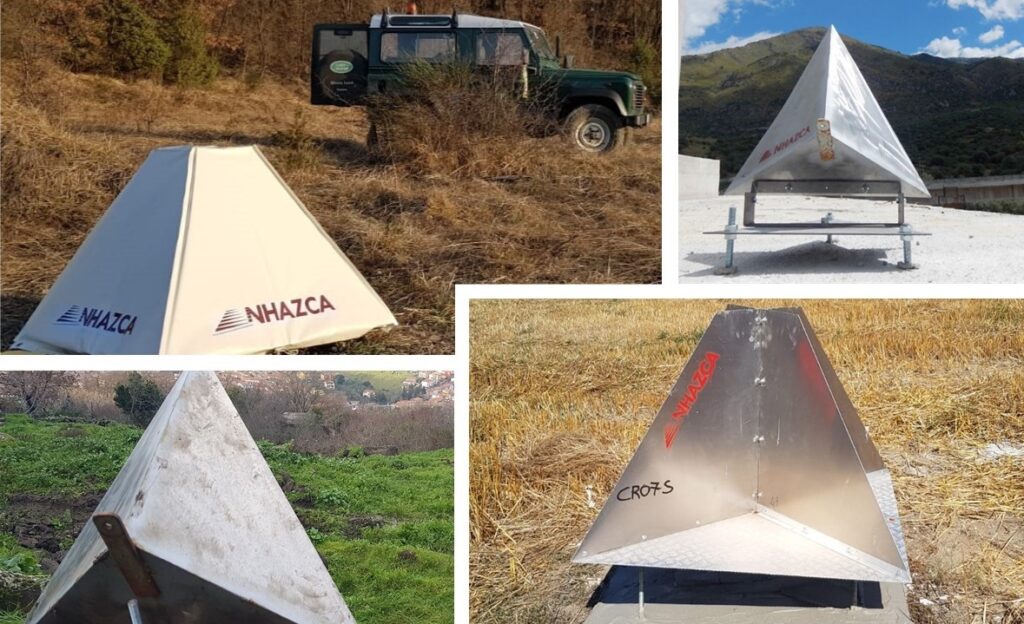
Corner Reflectors
As part of the monitoring services, NHAZCA offers the supply and installation of artificial reflectors (corner reflectors) of new concept, which can also be used for satellite InSAR analysis. The corner reflectors are passive targets designed to obtain a backscattered signal stable in time, allowing to obtain accurate displacement measurements.
These are metallic devices that do not require any power supply and/or maintenance after installation. Because of their own characteristics (material, shape and size), they allow to obtain monitoring points in strategic areas and to return accurate time series of displacement, especially in regions characterized by lack or scarcity of natural reflectors.
SUCCESSFUL APPLICATIONS
TRAINING
NHAZCA promotes, also in collaboration with professional organizations and associations in Italy and abroad, highly professional training courses, focused on geotechnical and structural monitoring, remote sensing applications and support to land use planning and design.
The courses, designed to provide skills and updates in line with continuous technological and cultural developments, have already seen the participation in the last 12 years of more than 700 professionals from over 50 countries with the involvement of over 60 companies.
9TH ICGSM
02 – 06 May 2023, Rome
The ninth Edition of the International Course on Geotechnical and Structural Monitoring will feature this year a large Expo Area to showcase the newest instrumentation, and run real demos.
Several thematic Courses & Workshops will be organized by leading scientists in the field to stimulate exchange of the latest scientific and technological knowledge and offer training and updating in new techniques.
PAST EVENTS
___________________________________2022___________________________________
___________________________________2021___________________________________
___________________________________2020___________________________________
- BC Hydro in-house training (Vancouver, BC)
___________________________________2019___________________________________
- VI International Course on Geotechnical and Structural Monitoring (Rome, Italy)
- Satellite InSAR for the displacement analysis in urban areas (ACEA – Rome, Italy)
___________________________________2018___________________________________
___________________________________2017___________________________________
___________________________________2016___________________________________
- III International Course on Geotechnical and Structural Monitoring (Poppi, Italy)
- Satellite InSAR for geologists and engineers (Rome, Italy)
- Terrestrial InSAR for geologists and engineers (Rome, Italy)
___________________________________2015___________________________________
- II International Course on Geotechnical and Structural Monitoring (Poppi, Italy)
- Satellite InSAR for geologists and engineers (Milan, Italy)
- Terrestrial InSAR for geologists and engineers (Milan, Italy)
- Satellite InSAR for geologists and engineers (Rome, Italy)
___________________________________2014___________________________________
___________________________________2013___________________________________
- International course on “Geotechnical Instrumentations for Field Measurements” (Cocoa Beach, Florida)
ABOUT NHAZCA
NHAZCA (Natural HAZards Control and Assessment), Startup Company of Sapienza University of Rome, is a international leader in the analysis and monitoring of natural hazards and large infrastructures for the management and mitigation of risks.
NHAZCA is strongly characterized by a highly integrated and motivated team which contributes to its success and growth over time. Our team consists of enthusiasts geologists, engineers, project managers, and technicians coming both from private and academic world, also benefiting from a world-class network. Since our foundation, our team has been growing extensively and our ambition is to continue to develop new solutions and services while expanding our geographic footprint. Each employee is a specialist in his or her field.
Thanks to the high technical and scientific expertise of its team and to the support of excellent scientific and commercial partners, NHAZCA organizes specialized training activities, with courses both at national and international level, with the aim to provide to end-users the necessary background about the latest innovations in the field of geotechnical and structural monitoring and in the analysis of natural hazards for risk mitigation purposes.
SUBSCRIBE TO THE NEWSLETTER
CONTACT US
NHAZCA S.r.l.
VAT Number: 10711191006
N.REA: RM-1250972
Share Capital: 40.000 €
Univocal Code: W7YVJK9
Registered office
Via Vittorio Bachelet, 12
00185 Rome (Italy)
Ph.: (+39) 06 95.065.820
PEC: nhazcasrl@pec.it
E-mail: info@nhazca.com